
AI tool may expose illegal beach construction in Mexico
Playas Libres IA uses public maps and building data to flag possible construction conflicts in Mexico’s federal beach zones.
A new AI project is turning Mexico’s coastal maps into easier-to-understand data. Built around a beach dispute in Bahía de Banderas, Playas Libres IA compares official federal beach boundaries with open building data. Its early findings do not prove illegality, but they raise questions that many beach communities already know well: who controls the shoreline, who gets access, and whether development is outpacing enforcement.
AI tool created to detect possible illegal building in federal beach zones
A new digital project called Playas Libres IA uses artificial intelligence and public mapping data to identify potential construction conflicts in Mexico’s federal maritime zone, known as ZOFEMAT.
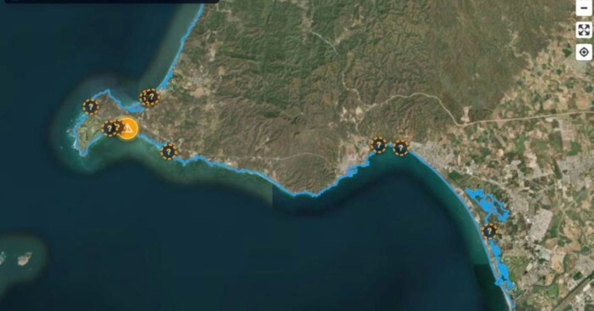
The project was developed around the case of Playa Las Cocinas in Bahía de Banderas, Nayarit. That beach has become part of a wider dispute over coastal development, public access, and the limits of private construction near the shoreline.
The tool compares official mapping from Semarnat with open building data. It then looks for places where construction footprints appear to overlap with the federal coastal strip.
Its early analysis flagged 107 possible cases in Bahía de Banderas where buildings may cross into the federal beach zone. The developer has stressed that these are not legal findings. They are data-driven alerts that would need review by authorities, surveyors, and legal experts.
That distinction matters. A map can show a possible overlap. It cannot decide whether a concession exists, whether the coordinates are correct, or whether a building has legal authorization.
Still, the project gives the public a new way to see a problem that is often hidden behind technical documents, permit language, and hard-to-read government maps.
How Playas Libres IA works
Playas Libres IA uses geospatial data. In basic terms, it places one map over another and checks where the lines meet.
One layer comes from official ZOFEMAT mapping. This shows the federally controlled strip beside beaches and some other coastal features. Another layer uses open building data, including mapped construction footprints.
When a building footprint appears within or over the federal strip, the system flags it as a potential case for review.
The project’s creator has described the tool as experimental. That is important because open data can be incomplete or outdated. Artificial intelligence can also misread information. Coastal mapping can be affected by tides, erosion, previous surveys, and shoreline changes.
The tool is best understood as a filter. It does not replace inspections. It helps point people toward locations where a closer look may be needed.
That could still be useful in beach towns where residents often struggle to get clear answers. Many coastal disputes turn on technical questions. Where does the federal zone begin? Where does private land end? Is a wall, terrace, foundation, pool, or beach club inside the public strip?
Those questions can take months to answer. A public map could help shorten the first step.
What Mexico’s federal beach zone means
In Mexico, beaches are not treated as private property in the way many foreigners may understand the term. Mexican law classifies maritime beaches and the Zona Federal Marítimo Terrestre as federal public-use property.
When a coastline has a beach, the ZOFEMAT is generally a 20-meter strip of firm, walkable land next to the beach. The exact legal boundary depends on technical measurements and official delimitations.
This does not mean no one can operate a business near the beach. Hotels, restaurants, beach clubs, marinas, and other projects may receive concessions, permits, authorizations, or related approvals.
But a concession is not the same as ownership of the beach. It gives permission to use or manage a defined area under specific conditions.
Mexican law also states that access to maritime beaches and the adjacent federal zone cannot be blocked, restricted, conditioned, or obstructed except as permitted by regulation. Where no public road or access exists, adjoining landowners may be required to allow access under terms agreed with federal authorities.
That is the legal framework. The practical reality can be more complicated.
In many beach destinations, access can be limited by walls, gates, security guards, terrain changes, private roads, or resort layouts. A beach may remain public on paper while becoming difficult to reach in daily life.
That gap between law and reality is where conflicts often begin.
Why the Las Cocinas case matters beyond Nayarit
The Playa Las Cocinas dispute has drawn attention because it sits in one of Mexico’s most visible tourism corridors.
Bahía de Banderas includes communities tied closely to Puerto Vallarta, Punta de Mita, Bucerías, La Cruz de Huanacaxtle, and other fast-growing coastal areas. The region has seen strong growth in hotels, residential, and luxury real estate.
That growth brings investment and jobs. It can also increase pressure on beaches, water supplies, roads, fishing areas, turtle habitat, and public access points.
For local residents, the issue is often not only one building or one permit. It is the feeling that communities are losing physical access to places they have used for generations.
For foreign residents and seasonal visitors, the issue can also be personal. Many people move to Mexico’s coast because the beach feels open and part of everyday life. When access becomes uncertain, it changes the character of the destination.
The Las Cocinas case has also shown how fast a construction dispute can become a governance problem. Residents have asked for clarity on permits, federal boundaries, environmental impacts, and public access. Authorities are then left to prove that enforcement is real, not only written in law.
Why AI may change beach access disputes
Coastal enforcement has long depended on official inspections, citizen complaints, and agency records. Those systems can be slow. They also require technical knowledge that many residents lack.
A public tool like Playas Libres IA could change that balance.
If the platform becomes publicly accessible, residents, journalists, researchers, and civic groups could review coastal boundaries without needing specialized mapping software. They could also compare visible construction with government data.
That does not mean every flagged property is illegal. It means questions can be asked with more precision.
Instead of saying a project “looks too close to the beach,” a resident could point to a specific mapped overlap. Instead of relying only on rumor, reporters could ask authorities about a defined location, concession, or permit.
This could create pressure for better transparency. It could also reduce confusion when a project is legal but poorly explained.
The risk is that preliminary data may be treated as proof. That would be a mistake. The tool’s value depends on careful use, clear disclaimers, and follow-up verification.
The limits of a map
A map can show a possible conflict. It cannot tell the whole story.
A building may appear within a federal zone due to a mapping error. A structure may have a valid concession. The federal boundary may have changed. A construction footprint may be old, incomplete, or wrongly placed in an open database.
There are also legal differences between a building, a temporary structure, a terrace, a seawall, a concession area, and land gained from the sea.
Those distinctions matter in enforcement.
For that reason, Playas Libres IA should be viewed as a starting point. It can help identify where to ask questions. It cannot answer every question on its own.
The stronger test will be whether authorities respond to those questions with public records, updated maps, and clear enforcement decisions.
A national issue for Mexico’s beaches
The project began with a case in Bahía de Banderas, but the issue is national.
Mexico’s coast includes major tourist destinations in Jalisco, Nayarit, Baja California Sur, Quintana Roo, Oaxaca, Guerrero, and Sinaloa. Many of those areas face the same pressures: real estate growth, beach clubs, private developments, limited public access, and weak public understanding of federal coastal rules.
The rise of tools like Playas Libres IA suggests that beach access disputes may no longer stay confined to closed files or local protests.
Public data can make these conflicts more visible. It can also make it harder for authorities to avoid explaining where the beach ends, where private land begins, and what construction is allowed in between.
That does not solve the problem. But it changes who can see it.