
Mexico Pacific hurricane season opens with El Niño risk
The 2026 Eastern Pacific hurricane season begins May 15 with forecasts calling for above-average activity and rising El Niño risk.
Mexico’s Pacific coast enters the 2026 hurricane season with an active outlook, unusually warm ocean conditions, and a developing El Niño that could make the basin more favorable for stronger storms. Forecasters are watching the possibility of a very strong El Niño later this year, though officials caution that “super El Niño” is not an official classification and its final strength remains uncertain.
Mexico’s Pacific coast enters a season already loaded with warning signs
The 2026 Eastern Pacific hurricane season officially begins today, May 15, opening a six-and-a-half-month stretch that runs through November 30. At the start of the season, the National Hurricane Center reported no active tropical cyclones in the Eastern Pacific, but the quiet opening day does not reduce the risk ahead. The basin’s long-term average is 15 named storms, eight hurricanes, and four major hurricanes, according to NOAA climatology.
This year’s forecast is already leaning above that benchmark. Mexico’s National Meteorological Service and Conagua have projected 18 to 21 named tropical cyclones in the Pacific, including nine or ten tropical storms, five or six Category 1 or 2 hurricanes, and four or five major hurricanes of Category 3 or higher.
Private forecasters are also warning of an active season. AccuWeather’s 2026 Eastern Pacific forecast calls for 17 to 22 named storms, nine to 13 hurricanes, four to eight major hurricanes, and six to nine direct impacts to Mexico or Central America. Its analysis points to elevated risk for Baja California Sur, Sinaloa, Michoacán, Colima, Jalisco, and Guerrero.
For Mexico, the meaning is direct. The Pacific basin does not need a record number of storms to cause major damage. One storm moving toward the wrong stretch of coastline at the wrong time can be enough.
Los Cabos Readies Hurricane Plan Before Storm Season
Los Cabos installed its Civil Protection Council before hurricane season, setting plans for shelters, evacuations, and storm response.
Puerto Vallarta Faces Above-Normal 2026 Cyclone Season
Puerto Vallarta is preparing for above-normal rain and higher cyclone risk as officials activate emergency coordination for 2026.
Puerto Vallarta installs storm council before rainy season
Puerto Vallarta installed its Civil Protection council to coordinate shelters, evacuation routes, and storm response before the rainy season.
Puerto Vallarta Prepares for a Busy Cyclone Season
Mexico expects an active Pacific cyclone season in 2026, with Puerto Vallarta watching rain, flooding, and coastal hazards.
Super El Niño Risk Raises Pacific Hurricane Concern
UNAM warns that a possible strong El Niño in 2026–2027 could deepen drought, intensify extreme rainfall, and increase Pacific hurricane risk.
The 2026 Eastern Pacific storm names
The names for the 2026 Eastern North Pacific season are:
Amanda, Boris, Cristina, Douglas, Elida, Fausto, Genevieve, Hernan, Iselle, Julio, Karina, Lowell, Marie, Norbert, Odalys, Polo, Rachel, Simon, Trudy, Vance, Winnie, Xavier, Yolanda, and Zeke.
The list is maintained through the World Meteorological Organization system and reused every 6 years unless a storm name is retired due to extreme death or destruction. The 2026 list will be used again in 2032 unless any names are removed after this season.
Why El Niño matters more in the Pacific
The key climate factor this year is El Niño, the warm phase of the El Niño–Southern Oscillation. During El Niño, surface waters in the central and eastern tropical Pacific become warmer than usual. Trade winds weaken, warm water shifts eastward, and the atmosphere reorganizes around that new heat source. NASA explains that this pattern can alter rainfall, winds, and storm formation across large parts of the world.
For hurricanes, El Niño usually has opposite effects in the Atlantic and the Pacific. In the Atlantic, it tends to increase wind shear, which can tear developing storms apart. In the central and eastern Pacific, it can reduce hostile wind shear and help storms maintain their structure. NASA notes that warmer eastern Pacific waters and favorable wind patterns can help tropical storms develop into hurricanes, while increased Atlantic shear can inhibit storm formation there.
That does not mean every El Niño year brings a disastrous Pacific hurricane season. It means the background environment can become more favorable for storm formation and strengthening. This year, the concern is that El Niño may develop while Pacific waters are already unusually warm, giving storms more fuel if other conditions line up.
The “super El Niño” question
The phrase “super El Niño” is attracting attention, but it needs careful handling. The World Meteorological Organization says it does not use “super El Niño” as a standardized operational classification. WMO said in April that El Niño was expected to develop from mid-2026 and that models suggested the event could become strong, but it also warned that forecast certainty is limited during the spring predictability barrier.
NOAA’s Climate Prediction Center issued an El Niño Watch on May 14. Its latest outlook gives El Niño an 82% chance of emerging during May-July 2026 and a 96% chance of continuing through the Northern Hemisphere winter of 2026-27. But NOAA also said the peak strength remains substantially uncertain, with no strength category exceeding a 37% chance.
That distinction matters. It is fair to say forecasters are watching the possibility of a very strong El Niño. It is not accurate to write as if a super El Niño is already confirmed.
For Mexico’s Pacific coast, the practical concern is not the label. The concern is whether El Niño, warm ocean water, and seasonal storm patterns combine to raise the risk of stronger storms, more rapid intensification, and more coastal rainfall events.
Rapid intensification is the lesson Mexico cannot ignore
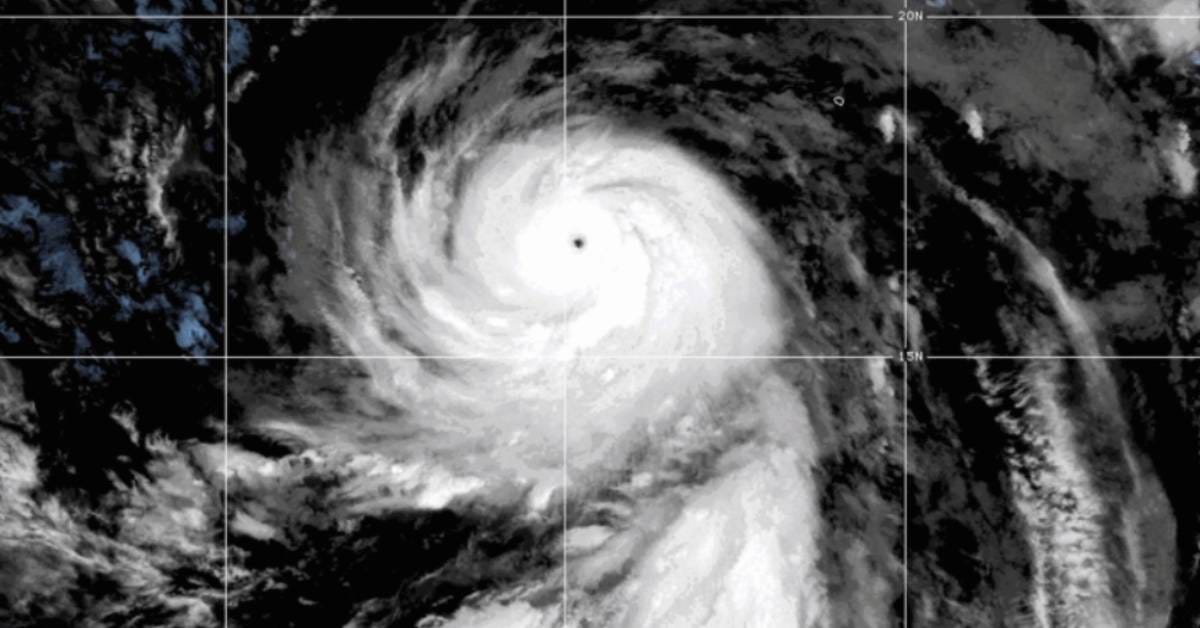
Recent storms have changed how coastal Mexico thinks about hurricane risk. Hurricane Otis remains the clearest warning. In October 2023, Otis made landfall near Acapulco as a Category 5 hurricane with sustained winds of 165 mph. NOAA described it as the strongest hurricane in the Eastern Pacific to make landfall in the satellite era.
Otis is now part of the public memory of hurricane season because it intensified so quickly near the coast. A rapidly strengthening storm leaves less time for warnings, evacuations, hotel preparations, port closures, and emergency response. That is especially dangerous along Mexico’s Pacific coastline, where mountains sit close to the sea, and heavy rainfall can trigger flash flooding and landslides even after winds weaken inland.
The same risk applies beyond the direct landfall zone. A hurricane passing offshore can still produce dangerous surf, rip currents, port disruptions, heavy rain bands, and flooding. A weaker storm can also cause serious damage if it stalls near the coast or moves slowly over steep terrain.
Where Mexico’s Pacific coast is most exposed
The Eastern Pacific basin stretches from the coasts of Mexico and Central America westward to 140°W. For Mexico, the exposed coastline includes Baja California Sur, Sinaloa, Nayarit, Jalisco, Colima, Michoacán, Guerrero, Oaxaca, and Chiapas.
The risk changes through the season. Early-season systems often form south of southern Mexico and can affect Oaxaca, Guerrero, Michoacán, and Colima. As the season progresses, storms may track farther west or northwest, bringing greater concern for Jalisco, Nayarit, Sinaloa, and Baja California Sur. In El Niño-influenced years, warm water and favorable steering patterns can sometimes allow tropical moisture or decaying systems to reach farther north than usual.
That does not mean every coastal community faces the same level of danger every month. It means the full Pacific coast needs to treat the season as a moving threat, not a single event.
Tourism centers face a special challenge. Puerto Vallarta, Los Cabos, Manzanillo, Ixtapa-Zihuatanejo, Huatulco, Acapulco, and other coastal destinations must prepare not only residents, but also visitors who may not know local evacuation routes, alert systems, or shelter protocols. Hotels, marinas, restaurants, condo towers, and short-term rental managers become part of the emergency chain when a storm approaches.
Why an active season does not guarantee landfalls
Seasonal forecasts estimate basin-wide activity. They do not predict exactly where storms will form, where they will make landfall, or how many will strike Mexico.
That is an important point for readers. A season with many named storms can still bring limited land impacts if systems curve away from shore. A quieter season can still produce one catastrophic landfall. For coastal preparedness, the number of storms matters less than the storm’s track, intensity, rainfall footprint, and speed of movement as it approaches land.
Forecasters use seasonal outlooks to identify elevated risk, not to issue local warnings months in advance. Local warnings come from real-time forecasts once a disturbance forms and models begin to narrow its likely path.
What residents and visitors should watch this season
The most important forecast product during the season is the National Hurricane Center’s Tropical Weather Outlook, which identifies areas of disturbed weather and their odds of development over the next two and seven days. NHC said the Eastern Pacific outlook is issued four times daily during the season.
For Mexico, residents should also follow Conagua, the Servicio Meteorológico Nacional, state civil protection agencies, municipal alerts, and official shelter notices. This matters because tropical cyclones are not only coastal wind events. Inland rainfall can be deadly, especially in mountainous areas and river communities.
A practical readiness plan should include checking the nearest shelter, protecting important documents, confirming insurance coverage, preparing medications, knowing how to turn off gas and electricity, and having enough drinking water, food, batteries, and phone power for several days. Foreign residents and visitors should also know where to find Spanish-language alerts and should not wait for English-language summaries before acting.
The season begins with uncertainty, not comfort
The start of hurricane season is not a prediction of disaster. It is a deadline for preparation.
This year, the warning signs are stronger than usual: an above-average Pacific forecast, unusually warm waters, elevated risk for parts of Mexico’s coast, and a developing El Niño that could make the basin more favorable for tropical activity. At the same time, forecasters are still uncertain about how strong El Niño will become, and the term “super El Niño” should be treated with caution rather than certainty.
The season may be active. El Niño may increase the risk environment. Rapid intensification remains a serious concern. But the difference between a dangerous storm and a disaster often comes down to preparation, clear warnings, and whether people act early enough.